- Mission: ICEYE’s goal is “to enable everyone to make better decisions based on timely & reliable Earth Observation data” iceye.com. The company operates an always-on radar imaging network that delivers objective, near-real-time insights worldwide.
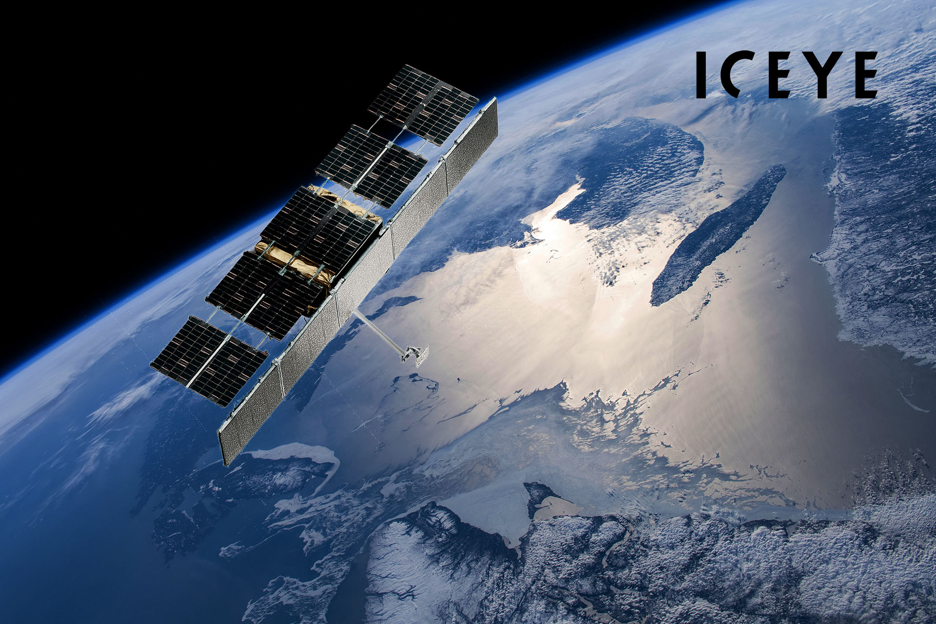
- Constellation: As of late 2025 ICEYE has launched over 50 SAR satellites (54 by its own count) into low Earth orbit, forming “the world’s largest SAR satellite constellation” economictimes.indiatimes.com, iceye.com. Its latest Gen4 satellites achieve up to 16 cm ground resolution across swaths of 400 km iceye.com.
- Core Services: ICEYE provides persistent all-weather Earth observation via Synthetic Aperture Radar (SAR). Key offerings include global monitoring (day/night, any clouds), flood and disaster impact mapping, wildfire and environmental monitoring, insurance loss assessment, and maritime/supply-chain surveillance thegreatentrepreneurs.com, prnewswire.com. It also sells turnkey SAR satellites and systems to governments.
- Customers: The ICEYE constellation supports military and government clients (Ukraine’s forces, NATO, Japan, Finland’s Ministry of Defense, etc.) as well as commercial and public-sector users. Major customers include national defense agencies, space agencies and weather services, insurers and reinsurers (e.g. MAPFRE Re, Aon, Juniper Re), and companies in maritime, utilities, and agriculture economictimes.indiatimes.com, insurancebusinessmag.com. For example, FEMA and UN agencies have used ICEYE flood data for disaster response, while insurers license its NatCat analytics to accelerate claims.
- Capabilities: ICEYE’s SAR satellites scan every point on Earth multiple times per day, providing depth and extent measurements for floods, hurricane damage, wildfire burn area, subsidence, and more. Their all-weather radar can “see through clouds” and darkness, building detailed surface images by timing radar echoes from 550 km altitude economictimes.indiatimes.com, reuters.com. This “persistent monitoring” enables clients to know ground conditions without guesswork lloyds.com.
- Scale & Growth: Founded 2014, ICEYE has raised over $500 million by 2025 (including a recent $93M round and $47M Finnish government grant) to expand its constellation and services thegreatentrepreneurs.com, economictimes.indiatimes.com. It employs 700+ staff globally, with offices in Europe, the US, Japan and beyond, reflecting its rapid scaling as a space-tech leader thegreatentrepreneurs.com, prnewswire.com.
Earth Observation and Persistent Monitoring
ICEYE’s core technology is Synthetic Aperture Radar (SAR) on microsatellites, which provides reliable imaging regardless of weather or daylight. In SAR, each satellite emits microwave pulses toward Earth and measures their echoes, constructing high-resolution pictures of the surface economictimes.indiatimes.com, arctictoday.com. As one ICEYE advisor explains, “these aren’t photographs… radio waves sent to the surface… [that] show what’s there even in snow, rain, fog or other extreme weather conditions”arctictoday.com. This means ICEYE can monitor regions 24/7: one new satellite can collect hundreds of images per day, and the full constellation delivers revisit times on the order of hours iceye.com.
According to Reuters, “ICEYE’s satellite constellation works by bouncing a radar beam off the surface… to build a picture of what is happening on the ground… regardless of weather conditions or daylight” reuters.com. The Gen4 satellites (debuted in 2025) push the frontier even further: they achieve 16 cm resolution and cover an expanded 400 km-wide swath iceye.com. In practical terms, this lets ICEYE capture extremely detailed imagery of infrastructure and landscapes. For example, a single Gen4 satellite can image an entire naval task force or a major border crossing in one pass iceye.com. By continually upgrading through software, ICEYE keeps its data “sharper, faster, and more flexible” for customers worldwide iceye.com.
From Arctic ice mapping to environmental monitoring, ICEYE’s SAR data is already applied in many civil uses. Early on, founders Rafal Modrzewski and Pekka Laurila proved SAR could track sea-ice channels and volcano lava flows even under clouds arctictoday.com. Today, ESA and environmental agencies tap ICEYE for climate applications. ICEYE satellites track flooding in Europe and Asia, wildfire perimeters in the Amazon, volcanic ash plumes in Iceland, and even ground deformation along dams and mines arctictoday.com, lloyds.com. As ICEYE’s insurance chief Stephen Lathrope notes, “the most significant story… is how space can help us manage climate change.” In short, ICEYE’s continuously updated SAR archives give scientists and planners unprecedented situational awareness about Earth’s surface.
Flood and Natural Disaster Monitoring
A key ICEYE application is rapid disaster impact assessment. By comparing pre- and post-event SAR images, clients get near-real-time maps of flood extent, storm surge, hurricane wind damage, wildfire burn scars and even earthquake destruction. For floods, ICEYE’s Flood Insights product delivers water-depth and inundation maps within hours of a flood peak iceye.com, insurancebusinessmag.com. NOAA’s responders and FEMA rely on this data to focus rescue efforts and model losses. In the 2024 Atlantic hurricane season, for example, ICEYE “delivered near real-time geospatial flood impact data to FEMA for major US flood events” iceye.com. Such information dramatically accelerates response; Lloyd’s of London reports that persistent SAR monitoring can provide “faster, fact-based event response and enable automated claims notification” in major floods lloyds.com.
ICEYE has also built specialized tools for insurers and governments. Its Hurricane Solution fuses radar flood maps with observed wind damage, while Wildfire Insights tracks fire spread. In 2025 ICEYE expanded to multi-peril analytics: a new “Earthquake with Fire Following” product (deployed initially in California) maps earthquake-induced structural damage and ensuing fires in near-real time reinsurancene.ws. As ICEYE’s insurance VP Rupert Bidwell explains, this capability “gives insurers critical insight at speed and scale as the event evolves, at a time when every hour counts for their customers” reinsurancene.ws. Clients can thus obtain building-level impact layers for complex events within hours, far quicker than traditional aerial surveys.
The business impact is material: major reinsurers are integrating ICEYE data into their catastrophe models. In mid-2025 MAPFRE Re licensed ICEYE’s global Flood Insights to feed its risk assessments insurancebusinessmag.com. MAPFRE noted that ICEYE “delivers flood extent and building-level inundation data within hours of an incident” insurancebusinessmag.com, even in regions (like Latin America) where timely EO data was scarce. Rupert Bidwell comments that licensing ICEYE data “equips [reinsurers] with the most current, high-resolution damage data available” insurancebusinessmag.com for their post-disaster response. Earlier deals with Juniper Re and Aon similarly bring ICEYE’s flood and wildfire analytics into global insurance operations. In summary, ICEYE’s SAR constellation is transforming disaster risk management by making objective impact data continuously accessible – and insurers and governments are capitalizing on this “unparalleled persistent monitoring capability” prnewswire.com.
Defense and Intelligence Applications
ICEYE’s military-grade services form a second cornerstone of its business. Its satellites are explicitly designed for intelligence, surveillance and reconnaissance (ISR). The company works as a “trusted partner” for NATO nations and allies prnewswire.com. For example, in March 2025 ICEYE announced that NATO’s Situation Center will receive direct SAR data feeds to enhance situational awareness prnewswire.com. Pekka Laurila (ICEYE’s Chief Strategy Officer) emphasizes that “ICEYE provides high-accuracy SAR satellite imaging and data to support situational awareness and decision making in defence and security settings” prnewswire.com. The Finnish and allied interest is clear: Finland’s government signed a recent letter of intent to procure its own ICEYE satellites for national ISR, recognizing that “acquiring our own satellites… strengthen[s] our independent space-based intelligence and surveillance capabilities” janes.com.
Technical specs underline the value for defense: the latest ICEYE sensors can achieve 25 cm or even sub-20 cm ground resolution prnewswire.com, iceye.com, allowing forces to identify individual vehicles or small structures. The satellites are also extremely agile: ICEYE’s next-generation ISR Cell (a containerized C2 unit) and AI analytics (like the joint “Detect & Classify” product) enable near-instant insights. John Cartwright, ICEYE’s Head of Data Products, explains that automating SAR analysis is a “fundamental shift” for military intelligence: “we’re eliminating a bottleneck… giving our users near-instant situational awareness… [enabling] ‘lights-out,’ machine-driven satellite imaging operations” iceye.com. In practice, this means a brigade commander or analyst can task ICEYE for a rapid image and get back classified detections of vehicles, aircraft or ships within minutes.
These capabilities have seen real-world use. During the 2025 Ukraine conflict, commercial SAR imagery (including ICEYE’s) was used to plan strikes and monitor battlefields. Reuters reported that Ukraine’s intelligence took thousands of ICEYE radar images of enemy positions, using them to prepare attacks and confirm results arctictoday.com. ICEYE CEO Rafal Modrzewski notes that the crisis underscored how “the future security of nations will be massively dependent on satellite constellations” reuters.com. Europe’s defense push (e.g. new EU space initiatives) is partly driven by companies like ICEYE. Indeed, ICEYE recently announced a $250 million expansion plan (supported by a €41 million government grant) to scale up space-based ISR technology economictimes.indiatimes.com, arctictoday.com.
In summary, ICEYE’s Defense/Intel services combine a globally unique constellation with advanced analytics. Its 24/7 SAR coverage fills in gaps that optical satellites or aerial drones cannot (e.g. night operations or bad weather). As a co-founder observes, “we have clearly ended up being in the right place at the right time with this technology” given rising security demands economictimes.indiatimes.com. Major governments are already leveraging ICEYE data for border surveillance, emergency response and force protection. Going forward, ICEYE expects to deepen collaborations with NATO, national space agencies, and allied forces by offering fully sovereign satellite systems and data feeds.
Commercial and Industry Use Cases
Beyond government and disaster sectors, ICEYE serves a wide range of commercial markets. Insurers and reinsurers have been a fast-growing customer segment, not just for nat-cat claims but for broader risk insights. The Lloyd’s market notes that ICEYE’s flood mapping allows insurers to deploy parametric products and novel covers for vulnerable communities lloyds.com. For example, ICEYE flood data powered a UNDP-backed parametric insurance facility that automatically triggers payouts to rural Ghanaian farmers after major floods lloyds.com. Reinsurance firms also embed ICEYE data into global catastrophe models: in 2025, MAPFRE Re and Aon joined Juniper Re in partnering with ICEYE to incorporate continuous flood and wildfire intelligence into their analytics insurancebusinessmag.com. These partnerships demonstrate ICEYE’s market impact – making satellite imagery a routine part of financial risk management.
Another key commercial market is maritime domain awareness. Many commercial operators (shipping companies, fisheries regulators, insurers) need to track vessel movements globally. ICEYE’s SAR satellites excel at detecting “dark” ships that turn off AIS transponders. In a 2025 collaboration with satellite data firm Spire, ICEYE launched a new service that fuses SAR imagery with AIS data to spot illegal fishing and smuggling at sea iceye.com. Pekka Laurila explains this “new… ability to monitor maritime traffic, including vessels that want to avoid detection” iceye.com. By imaging wide ocean areas day or night, ICEYE can repeatedly scan a given sea lane, automatically flagging unexpected targets. The result is stronger monitoring of exclusive economic zones (EEZs) and shipping lanes. Spire concurs on the value of data fusion: “By combining data sets like AIS and SAR, we gain unrealized insights in the movement of goods and people around the globe,” says Spire’s maritime lead John Lusk iceye.com. Thus, ICEYE is helping port authorities, coast guards and insurers gain unprecedented visibility into marine traffic, enhancing security and compliance.
Other industrial uses include utilities and energy (monitoring pipelines, dams and transmission lines for sagging or subsidence), agriculture (soil moisture and crop monitoring in cloud-prone regions) and environmental stewardship (tracking deforestation and infrastructure). While ICEYE’s primary go-to-market has been insurance, defense and government, it is actively expanding into these sectors as well. Its high revisit imaging is well-suited to fast-changing assets like mining operations or offshore oil platforms. In fact, ICEYE’s contracts include corporate users who use SAR for asset protection and operational planning.
Finally, ICEYE’s strong market position is recognized by analysts: it was named one of Via Satellite’s “10 Hottest Companies for 2025,” and even made TIME magazine’s list of top GreenTech firms for its role in climate resilience. The broader SAR market is booming – one report projects it growing from $32 billion in 2025 to $83 billion by 2035 futuremarketinsights.com – and ICEYE is widely seen as a leader. Its ongoing injection of capital and talent has positioned it to capture this demand. As ICEYE CFO Susan Repo recently noted, the company’s expansion “address[es] the increasing need for space-based technology” across industries thegreatentrepreneurs.com.
In sum, ICEYE has turned a small microsatellite into a global “constellation of watching eyes.” Its clients span governments, NGOs, insurers and businesses that need unbiased, up-to-date information about Earth. By coupling advanced SAR technology with AI analytics and cloud delivery, ICEYE delivers “persistent monitoring” that translates into faster decisions, stronger security and better-managed risk for its customers prnewswire.com, iceye.com.
Sources: Authoritative company announcements and news reports were used, including ICEYE’s official publications iceye.com, insurancebusinessmag.com, NATO and financial press releases prnewswire.com, insurancebusinessmag.com, Reuters and Economic Times articles economictimes.indiatimes.com, reuters.com, and industry analyses from Lloyd’s and reinsurance media lloyds.com, reinsurancene.ws. Each source is cited inline.