- New this year: NASA & ISRO launched NISAR on July 30, 2025, a dual‑band SAR mission designed to track crop development, plant health, and soil moisture throughout the season. NASA Science
- “Real time” ≠ instant: Space agencies define near‑real‑time (NRT) as data available 1–3 hours after observation; many routine “standard” products arrive within 8–40 hours. NASA Earthdata
- Revisit & latency today:
– PlanetScope (commercial): daily, with sub‑day delivery for some analytics;
– Sentinel‑2 (Copernicus): ~5‑day global revisit (now A/B/C);
– Landsat‑8/9: 8‑day combined revisit;
– SMAP (soil moisture radiometer): global coverage every 2–3 days, with NRT <3 hours latency;
– Sentinel‑1 / NISAR (radar): all‑weather imaging, routine 6–12 day coverage globally (NISAR samples Earth ~every 6 days on average). NASA Science - Plant health from space: Optical sensors (e.g., Sentinel‑2’s red‑edge bands) track chlorophyll, LAI and leaf water content; thermal sensors (e.g., Landsat/ECOSTRESS) map crop evapotranspiration (ET) and heat stress. European Space Agency
- Soil moisture at multiple depths: SMAP’s passive L‑band radiometer provides 36‑km surface soil moisture; data assimilation yields root‑zone (0–100 cm) soil moisture at ~9 km; fusion with Sentinel‑1 enables 1–3 km surface products. MDPI
- Yield estimation is operational in many settings: Research and operational systems now fuse satellite vegetation indices with weather to forecast yields; corn forecasting is particularly robust with MODIS‑type indices. PMC
- Market transparency & early warning: GEOGLAM’s Crop Monitor synthesizes satellite+ground data monthly for global crop condition maps used by governments and traders. GEOGLAM Crop Monitor
- Policy & compliance: The EU’s Area Monitoring System (AMS) uses Sentinel‑1/2 to verify CAP compliance, increasingly replacing field inspections. JRC: EU Science Hub
- Real‑world ROI: Landsat‑based ET monitoring helped California growers cut groundwater pumping by 13% in one year (~$40M savings). Maven’s Notebook
- Important nuance: Some official statistics programs (e.g., parts of USDA NASS yield forecasting) still do not directly use remote sensing in the final operational estimates, relying on surveys instead. data.nass.usda.gov
Expert soundbites
- “The key variable to track is surface soil moisture.” — Dara Entekhabi, SMAP science lead. MIT News
- “Imaging the planet more regularly can help many global challenges.” — Will Marshall, Planet co‑founder. DBL Partners
- “Satellite data provide an extra layer of information and can alert farmers of potential issues well in advance.” — Inbal Becker‑Reshef, Director, NASA Harvest. NASA Harvest
- “Sentinel‑2 … [provides] data on numerous plant indices.” — ESA Sentinel‑2 team. European Space Agency
- “Near real‑time (NRT) refers to data available 1 to 3 hours after an observation.” — NASA Earthdata. NASA Earthdata
- “Operational users … need a latency of under 3 hours.” — NASA SMAP on NRT products. SMAP
- “Two‑ to three‑day revisit time is particularly beneficial for cloudy areas.” — Cole Krehbiel, LP DAAC, on HLS Vegetation Indices. NASA Earthdata
- “We are significant users of Landsat on a daily basis.” — Joel Kimmelshue, Land IQ. Maven’s Notebook
- “NISAR will … map crop growth, track plant health, and monitor soil moisture.” — NASA. NASA
- “High‑resolution (3 km and 1 km) soil moisture is useful for agriculture.” — JPL/NASA SMAP‑Sentinel team. NASA Technical Reports Server
- “NASS’s operational crop yield forecasting … makes no use of remotely sensed data.” — USDA NASS methodology note. data.nass.usda.gov
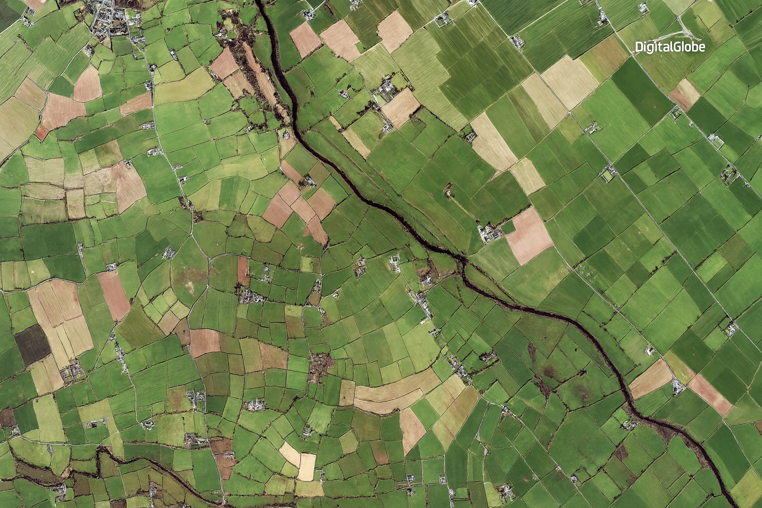
1) What satellite crop monitoring actually measures
Plant status (optical & thermal):
Multispectral imagers (Sentinel‑2, Landsat, PlanetScope) quantify greenness (NDVI/EVI), chlorophyll (red‑edge indices), and canopy water (NDWI/NDMI), proxies for vigor and stress. Sentinel‑2’s unique red‑edge bands (705–783 nm) sharpen sensitivity to chlorophyll and LAI—useful where NDVI saturates. Thermal sensors (Landsat TIRS, ECOSTRESS) estimate evapotranspiration (ET), a powerful indicator of crop water use and heat stress. eros.usgs.gov
Soil water (microwave):
Passive L‑band radiometers (NASA SMAP; ESA SMOS) sense surface soil moisture through clouds and light vegetation. SMAP’s standard grid is 36 km, but data assimilation provides root‑zone moisture (~0–100 cm) at 9 km, and active–passive fusion with Sentinel‑1 (C‑band SAR) yields 1–3 km surface moisture in many regions. MDPI
All‑weather structure (radar/SAR):
C‑, L‑ and X‑band SAR penetrate clouds and, to varying degrees, vegetation canopies. They’re valuable for cloudy seasons, flood mapping, tillage/harvest detection, and soil moisture retrieval where vegetation loads are modest. The 2025 launch of NISAR adds routine L+S‑band monitoring for agriculture at global scale. Copernicus
2) Platforms & constellations you’ll actually use Public, free
- Sentinel‑2 (Optical): 10–20 m, 13 bands (incl. red‑edge), ~5‑day revisit (A/B/C); global, open data. European Space Agency
- Landsat‑8/9 (Optical + Thermal): 30 m optical + 100 m thermal, 8‑day combined revisit; global, open data. Landsat
- Sentinel‑1 (C‑band SAR): All‑weather crop monitoring; widely used in EU compliance and soil moisture fusion. JRC: EU Science Hub
- SMAP (Passive L‑band): Surface soil moisture at 36 km, NRT <3 h, plus L4 root‑zone at 9 km (model‑assimilated). National Snow and Ice Data Center
- NISAR (L+S‑band SAR, launched 2025): Maps crop growth, plant health, soil moisture with ~6‑day sampling on average. NASA
Commercial
- PlanetScope (Doves): 3–5 m, daily optical; analytics like Crop Biomass delivered with <12 h latency in many regions. docs.planet.com
- High‑res SAR (Capella, ICEYE, Umbra): Sub‑meter to 25 cm radar for cloud‑independent field monitoring and soil‑moisture‑sensitive analytics. capellaspace.com
3) Soil moisture from space: from topsoil to root zone
- Surface layer: SMAP L2/L3 products provide 36‑km surface moisture every 2–3 days; NRT variants are available within ~3 hours for operational users. NASA Earthdata
- Downscaled maps: SMAP–Sentinel fusion delivers 1–3 km soil moisture with unbiased RMSE near 0.05 m³/m³ in areas of low vegetation density, enabling field‑scale water management and drought mapping. NASA Technical Reports Server
- Root‑zone (0–100 cm): The SMAP L4 model‑assimilated product provides surface and root‑zone moisture at ~9 km resolution, directly supporting irrigation scheduling, drought indices and yield modeling. Google for Developers
- Europe’s ASCAT & Copernicus: Long climate records and near‑real‑time surface/root‑zone products complement farm operations and drought monitoring. www-cdn.eumetsat.int
4) Plant health & water stress: beyond NDVI
- Red‑edge matters: Sentinel‑2’s red‑edge bands improve sensitivity to chlorophyll/LAI versus classic NDVI, catching stress earlier. European Space Agency
- Thermal ET for irrigation: Landsat and ECOSTRESS map evapotranspiration, revealing over/under‑irrigation and heat stress; ET is the “crop water use” metric water managers act on. Landsat
- Harmonized Landsat–Sentinel (HLS) VIs: New 30‑m vegetation indices every 2–3 days markedly aid ag monitoring—especially where clouds limit single‑mission coverage. NASA Earthdata
5) Yield estimation from space
- How it works: Most operational yield models blend satellite vegetation time‑series with weather and sometimes management data. Research shows corn forecasting is especially robust with satellite greenness metrics; soy and wheat vary by region. USDA NASS
- Emerging operational tools: NASA Harvest’s new ARYA model and commercial indices like Planet’s Crop Biomass support in‑season yield outlooks and early deviations from normal. NASA Harvest
- Why it matters: Studies show satellite‑based forecasting can dampen food‑price volatility by informing markets earlier. NASA Harvest
- Caveat: Some statistical agencies (e.g., USDA NASS) still base official yield forecasts on surveys and objective field measurements, not satellite data, though RS informs many complementary analyses. USDA NASS
6) Turning “near real‑time” pixels into decisions
Know the limits of “real time”: Two factors govern timeliness—revisit (how often the satellite can see you) and latency (how fast products are published). Agencies define NRT as 1–3 hours post‑acquisition; commercial analytics can arrive within hours; but cloud cover and acquisition plans still create gaps. Blend Planet daily optical with SAR for cloudy periods to achieve truly routine monitoring. NASA Earthdata
Example pipelines by job-to-be-done
- Irrigation & water accounting: Thermal ET (Landsat/ECOSTRESS, OpenET‑style workflows) + SMAP L4 root‑zone for planning; SAR for cloud gaps → dashboards for pumping limits, allocations, and deficit irrigation. Real‑world case: 13% groundwater reduction, $40M saved in California. eros.usgs.gov
- Nutrient & disease scouting: Red‑edge indices (Sentinel‑2; PlanetScope SuperDoves) to spot sub‑field anomalies earlier; task drones/boots when satellite indices deviate from baseline. European Space Agency
- Compliance & MRV: EU AMS uses Sentinel‑1/2 to verify practices; supply‑chain MRV platforms (e.g., Regrow) quantify adoption of no‑till/cover‑crops and Scope‑3 outcomes with Landsat/Sentinel time series. JRC: EU Science Hub
7) Public programs & ecosystems that matter
- GEOGLAM Crop Monitor: Monthly, consensus crop condition reports used by FAO/AMIS and markets for early warnings. GEOGLAM Crop Monitor
- NASA Harvest: UMD‑led consortium operationalizing ag EO for decisions, including new yield models and market transparency work. NASA Harvest
- EU CAP monitoring: Sentinel‑1/2 power area monitoring; the Tools4CAP briefs outline how satellites now underpin eligibility checks. TOOLS4CAP
8) Buyer’s guide: choosing sensors & services
| Need | Best-fit sensors | Why |
| Daily plant vigor | PlanetScope, Sentinel‑2 | cadence (daily/5‑day), red‑edge sensitivity. docs.planet.com |
| Cloud‑proof continuity | Sentinel‑1, NISAR, commercial SAR | all‑weather, structure & moisture sensitivity. NASA Science |
| Irrigation/ET | Landsat (thermal), ECOSTRESS | field‑scale ET and heat stress. Landsat |
| Soil moisture, quick‑look | SMAP L2/L3 NRT | global 2–3‑day coverage, <3 h latency. NASA Earthdata |
| Soil moisture, field‑scale | SMAP–Sentinel 1–3 km | higher‑res moisture for management. NASA Technical Reports Server |
Platforms to consider (examples):
- Open & free: Copernicus Open Access (Sentinels), USGS EarthExplorer (Landsat), NASA Earthdata (HLS VIs, SMAP L4). documentation.dataspace.copernicus.eu
- Commercial & turnkey: PlanetScope daily monitoring; high‑res SAR (Capella/ICEYE/Umbra) for cloudy seasons; enterprise MRV (Regrow) for supply‑chains. docs.planet.com
9) Known pitfalls & how to handle them
- Clouds & shadows: Blend optical with SAR; use HLS to densify time series. NASA Earthdata
- Index saturation in dense canopies: Prefer red‑edge indices or EVI where NDVI tops out. PMC
- Soil moisture under heavy vegetation: Active–passive fusion works best where vegetation water content is modest; be cautious in dense crops. NASA Technical Reports Server
- “Ground truth” still matters: Cal/val networks and selective scouting remain essential—note that some official yield stats still rely on surveys. USDA NASS
- Latency vs. revisit confusion: Even NRT products can’t help if the satellite hasn’t passed recently; pair daily optical with SAR or NRT radiometry for resilience. NASA Earthdata
10) What’s next (2025–2028)
- NISAR operations: Global L+S SAR should standardize all‑weather crop and soil‑moisture monitoring, complementing Sentinel‑1. NASA Science
- Higher‑frequency, harmonized indices: HLS Vegetation Indices at 30 m every 2–3 days accelerate anomaly detection at field scale. NASA Earthdata
- Finer soil‑moisture maps: Continued SMAP downscaling (to 1 km) and SMAP–Sentinel fusion products are maturing for operations. Acsess
Useful links (by topic)
- Sentinel‑2 plant indices & red‑edge: ESA overview; Copernicus mission docs. European Space Agency
- Soil moisture basics & products: SMAP L2/L3/L4 at NSIDC; SMAP–Sentinel fusion & evaluations; ESA SMOS. documentation.dataspace.copernicus.eu
- Harmonized Landsat‑Sentinel (HLS) Vegetation Indices: NASA Earthdata news & access. NASA Earthdata
- GEOGLAM Crop Monitor: Global and Early Warning portals. GEOGLAM Crop Monitor
- Revisit & latency references: Sentinel‑2 5‑day revisit; Landsat 8‑day combined; NRT definitions & SMAP NRT latency. SMAP
Appendix: Selected studies & notes on yield‑from‑space
- Deep learning yield models: CNN‑LSTM improves county‑level soybean yield prediction. PMC
- Performance by crop: MODIS NDVI shows robust corn forecasting; wheat/soy results vary by location and method. USDA NASS
- Economic impacts: Satellite forecasting can stabilize prices during shocks (e.g., wheat/soy). Nature